15 years ago John came to Argentina to climb Cerro Aconcagua by a more technical route. This year Kathleen wanted to try so we agreed to try the “Normal Route” which on the surface is considered a walk up. That walk up however is to an altitude of 22,841 feet (6962 meters) which makes it a serious climb no matter which way you go. Typically the summit success rate for this mountain is only about 30%. This year the strongest El Nino in history is making the season one of the most difficult in 30 to 40 years according to the guides there so the success rate is far below 20%.
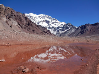
 First view of mountain from road
On John's first summit (Polish Glacier Route) there was months
of planning and organizing from the US involved. This time there was
almost no pre-planning. We had some gear and clothing with us but
the plan was to arrive in Mendoza (the gateway to Parque Provincial
Aconcagua) and figure it out on the fly. Limited with our packing space since we are traveling for several months afterwards, we opted to supplement our cold weather clothing with anything extra we needed for high
altitude mountaineering at a local rental shop. We would also arrange mule transport to carry food and equipment to
Base Camp and arrange permits to climb the mountain there. In two days
we were able to get everything done that we needed though it took
some scrambing and our credit card company shut down our credit card
due to the large amounts of money we were spending. While we were
doing this we heard that so far only 15 people had summited instead
of the usual 350 people by that time of year and half of those
“successful” people had to be evacuated for frost bite and one
had died by accidently walking off of the South Face. Not an
encourgaging statistic. We met a girl named Bri from Seattle at the
gear rental store who gave us some great information about the
mountain; most notably about
the high winds and heavy snow that she and her team had just experienced while there.
Once the preliminary work was done we caught a 3 hour ride back
up the road toward Santiago, Chile to the little ski resort of Las
Penitentes. This is where the two trailheads to the mountain are
located depending on which side of the mountain is being climbed. We
were to head up the Horcones River valley to the Base Camp at Plaza
de Mulas. It is a two day hike to Plaza de Mulas but as soon as we
arrived at the intermediate camp at Confluencia we started feeling
the effects of the altitude. This camp is at 11,119 feet and neither
of us had had any signs of AMS (acute mountain sickness) at this
altitude before. The trick with big mountains like this is
distinguishing between the annoying mild symptoms and the more life
threatening moderate to severe symptoms which can progress to fluid
buildup in the lungs or brain swelling. John had never felt that
poorly at that low of an altitude and Kathleen didn't feel
that great either. Because of these symptoms it was elected to spend an extra
night at Confluencia and to spend a day hiking out to a place called
Plaza Francia and back. This was well worth the time since the hike
takes you to the bottom of the magnificent South Face of Aconcagua.
This is the side of the mountain where legends and climbing carreers
have been made. A person has to be pretty much crazy and extremely
skilled to climb routes here due to the very steep nature of the
terrain and severe avalanche risk.
 View near Plaza Francia
 Shrine near Plaza Francia
 Mules carrying loads up Horcones Valley
Spending the extra day here helped with our symptoms so that the next day we were able to continue on to the Plaza de Mulas Base Camp. This is a small tent city where 100 to several hundred climbers are located depending on the day and time of season. We were self supported but for people willing to pay for it there are dome dorm tents to sleep in and full meal support.
 View near Plaza Francia
  Shrine near Plaza Francia
  Mules carrying loads up Horcones Valley
Spending the extra day here helped with our symptoms so that the next day we were able to continue on to the Plaza de Mulas Base Camp. This is a small tent city where 100 to several hundred climbers are located depending on the day and time of season. We were self supported but for people willing to pay for it there are dome dorm tents to sleep in and full meal support.
 Sunset behind Base Camp
From here it was time to start a process called double carrying
following the principal of “Climb high, Sleep low” as we moved up
through the 3 high camps. We would spend a day climbing up to the
next high camp, leaving a cache of food and fuel. We then would
climb back down to where we started and spend the night. The next
day we would grab our tent and clothes and make the permanent move up
to that higher camp.
 View from Camp Canada
We were fortunate with good weather until we had our food and fuel for 7 days stashed at Camp 2 which is called Nido de Condores. Here we heard that a large multi-day storm was coming so we elected to leave our supplies there and retreat to Base Camp where we would be more comfortable during the storm. Nido de Condores is very exposed to wind being on a ridgeline. We were glad we did this as the next couple of days were rough. Snow and thunder where we were with heavy rain in the valleys below us. We have not been in too many thunder-snowstorms and they are always intense.
 Lenticular cloud and fresh snow
Multiple landslides washed out the road between Penitentes and Mendoza. This caused the parks rescue helicopter to be busy further down the valley. Since there was no ability to rescue climbers the Park Service closed and evacuated the entire upper mountain. The linked video clip shows what was going on lower down as climbers were trying to hike back out to the road. It was a bit of a mess.
https://youtu.be/jNVwspunNn0 View from Camp Canada
 We were fortunate with good weather until we had our food and fuel for 7 days stashed at Camp 2 which is called Nido de Condores. Here we heard that a large multi-day storm was coming so we elected to leave our supplies there and retreat to Base Camp where we would be more comfortable during the storm. Nido de Condores is very exposed to wind being on a ridgeline. We were glad we did this as the next couple of days were rough. Snow and thunder where we were with heavy rain in the valleys below us. We have not been in too many thunder-snowstorms and they are always intense.
 Lenticular cloud and fresh snow
Multiple landslides washed out the road between Penitentes and Mendoza. This caused the parks rescue helicopter to be busy further down the valley. Since there was no ability to rescue climbers the Park Service closed and evacuated the entire upper mountain. The linked video clip shows what was going on lower down as climbers were trying to hike back out to the road. It was a bit of a mess.
We ended up being stuck at Base Camp for 4 days waiting for the
weather to break. We had to ration our food for these days as our
best food was at Camp 2 but luckily some of the things that we hadn't
wanted up higher like pasta had been left at Base Camp. We played
lots of cards, took some short hikes, slept a lot, and obsessively
checked the weather report.
Eventually a weather window started to form that looked like it
would be our only chance to make the summit before our permit ran out
after 20 days. The first few days of climbing would still be during
the storm but if we could get into position higher up on the mountain
then we would have a couple of nicer days to try to reach the top.
On 27 January 2016 we started up and spent the night at Camp 1 (Camp
Canada). During that night it started to storm and snow heavily
again. Waking up the next morning was discouraging and this was the
morning of John's crisis in confidence. Our options weren't good no matter
what we did. Staying at Camp Canada was the poorest choice as we
were going to run out of food and fuel that day. Choice 2 was to
descend to Base Camp basically giving up on the summit and we still
would have to go back up to Camp 2 (Nido de Condores) to get our
equipment. That left Choice 3 which is what Kathleen pushed for –
to climb up to Camp 2 in the midst of the storm. It would suck for
several hours but then we would be in better position for the weather
to end and we would have pretty much unlimited food and fuel. This
is what we ended up doing. John's mantra for the day became “Just
a typical day in the Alaska Range” as he reminded himself that it
had been as bad or worse when climbing Denali.
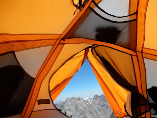
 Just another day in the Andes
Once we had made the move we were happy though the next morning the park rangers informed us that we had set up our tent in the helicopter landing area so we had to move.
 Move it before a helicopter hits it
 Just another day in the Andes
Once we had made the move we were happy though the next morning the park rangers informed us that we had set up our tent in the helicopter landing area so we had to move.
 Move it before a helicopter hits it
From here we got our break. The weather improved so that we
were able to move up to Camp 3 or Camp Colera which means Camp Angry
though we thought at first it was named after Cholera, the disease.
Either way, not the best named camp. We didn't spend much time
there.
 Scramble section up to Camp 3
That night we woke up at 3am to start melting snow for the day and to eat breakfast. At 5am we started up on our summit push. We could already see a line of headlamps dotting the hillside above us as other people made their way up the hill. It was intensely cold. Kathleen is very sensative to cold in her hands and was having some issues at first but we were able to get things under control with chemical hand warmers, and 3 layers of gloves/mittens. By the time the sun came out and we were able to turn the headlamps off we were about 1/3 of the way up. The sun burst with a red line on the horizon that then spread to the clouds below us and eventually we could see the shadow of the mountain cast onto the sky.
 Sunrise shadow of Aconcagua
Soon after this we got stuck behind the group that we dubbed “The Boy Scouts”. These guys did not look good. Some of them were staggering and barely moving along. John had kept warm until this point where upon he had to put his big puffy parka on. There was no room to get around these guys since the trail was very narrow with ice on either side. They were the first group that we had encountered that did not allow faster people behind them to go by. Very frustrating to be stuck behind and it was cold to be standing there waiting for them to move. After an insuffurably long time they finally took a break and we were able to get by. The top 1/3 of the climb is called the Canuleta. It is an area of very loose dirt and small rocks that is frustrating to climb as one slides back a foot for every two feet climbed. This year the extra amount of snow turned out to be a blessing. Cramponing up this snow made the route much easier though the thin air still made it rough. We would take a few steps and then stop for 4 breathes or more. It was slow but steady going. The Canuleta led up to the summit ridge and then the summit block.
 Summit ridge and South Summit
 View down South Face
We had been able to move efficiently enough that by the time we summited we were the 4th and 5th person on the summit that day. Now that the sun was out it had warmed up and we were able to spend about 20 minutes on the summit. 3 Chileans arrived right after us. There were still extensive views but there was a growing number of clouds building up below us. The Chileans and us took turns taking picutures for each other and then it was time to start going down.
 Scramble section up to Camp 3
 That night we woke up at 3am to start melting snow for the day and to eat breakfast. At 5am we started up on our summit push. We could already see a line of headlamps dotting the hillside above us as other people made their way up the hill. It was intensely cold. Kathleen is very sensative to cold in her hands and was having some issues at first but we were able to get things under control with chemical hand warmers, and 3 layers of gloves/mittens. By the time the sun came out and we were able to turn the headlamps off we were about 1/3 of the way up. The sun burst with a red line on the horizon that then spread to the clouds below us and eventually we could see the shadow of the mountain cast onto the sky.
 Sunrise shadow of Aconcagua
Soon after this we got stuck behind the group that we dubbed “The Boy Scouts”. These guys did not look good. Some of them were staggering and barely moving along. John had kept warm until this point where upon he had to put his big puffy parka on. There was no room to get around these guys since the trail was very narrow with ice on either side. They were the first group that we had encountered that did not allow faster people behind them to go by. Very frustrating to be stuck behind and it was cold to be standing there waiting for them to move. After an insuffurably long time they finally took a break and we were able to get by. The top 1/3 of the climb is called the Canuleta. It is an area of very loose dirt and small rocks that is frustrating to climb as one slides back a foot for every two feet climbed. This year the extra amount of snow turned out to be a blessing. Cramponing up this snow made the route much easier though the thin air still made it rough. We would take a few steps and then stop for 4 breathes or more. It was slow but steady going. The Canuleta led up to the summit ridge and then the summit block.
 Summit ridge and South Summit
 View down South Face
 We had been able to move efficiently enough that by the time we summited we were the 4th and 5th person on the summit that day. Now that the sun was out it had warmed up and we were able to spend about 20 minutes on the summit. 3 Chileans arrived right after us. There were still extensive views but there was a growing number of clouds building up below us. The Chileans and us took turns taking picutures for each other and then it was time to start going down.
 Summit - 22,841 feet
At the bottom of the Canuleta we came across a party of South
Africans that we had been climbing next to pretty much from the first
days of the expedition. They had become good friends and we had said
that if they did not summit then our expedition would feel like a
partial failure. Their expedition was led by a man named Alex Harris
who had climbed all of the 7 Summits (highest mountain on each
continent), skied to the South Pole, and most impressive to John, had
been part of the first team to cross the Empty Quarter of the Arabian
Desert self supported by pulling a 1000+ pound cart of food and water
along with Marco Broccardo who was also on the trip. Their team had
all sorts of problems. Team mates had lost their luggage on the
flights to South America, people had gotten sick, tents and equipment
had blown away, along with a bunch of smaller problems. They also
ended up summiting but then when they hiked out it turned out that
there was a bridge washed out so they still ended up missing their
flights back to South Africa which cost them an extra $1000+. We
felt pretty sorry for them but were psyched that most of them had
succeeded.
After taking 16 days to climb to the summit it only took 2 days
to hike back out to the road. We were ready to be out of there and
put our heads down and hiked out as quickly as possible. For days we
had been fantasizing about food. As soon as we got back to the hotel
in Penitentes the first priority was a shower. This was rapidly
followed by finding cold beer and a good bottle of wine. The
climatic finalle of the night was dinner. John had one of the best
steaks ever while Kathleen had a huge hunk of salmon. Fantasy
and reality merged into an explosion of culinary delight.
We were glad to be done and to have made the summit. Neither of us
planned on going back and trying again if we hadn't reached the top so it felt
good to have accomplished our goal. We had made friends from all
over the world, climbed in a beautiful part of the Andes, and
overcome a lot of obstacles. The next day we caught the bus back to
Mendoza and started our process of moving south into Patagonia for
further adventures in the mountains.
Well done guys! It's amazing to follow along with your adventures! ~Your Dentist
ReplyDeleteLove the blog post and the pictures.
ReplyDeleteGatwick meet and greet parking
meet and greet gatwick airport
The journey is all that matters. For some its just soothing.
ReplyDeletesecure airport parking Heathrow
Heathrow parking deals
This is very good information
ReplyDeleteI am happy because now I can find really good references
I hope you continue to share other interesting info that can certainly spoil the readers
Obat Penyakit Gondongan Cara Mengobati Kutu Air Di Sela Jari Kaki & Tangan Obat Penghilang Benjolan Di Payudara Obat Asma yang Direkomendasikan Oleh Dokter Bahaya Sering Cegukan Cara Mengatasi Vagina yang Terasa Gatal Bahaya Benjolan di Ketiak Obat Kecetit Obat Rangen Cara Menghilangkan Gatal Pada Kulit