Ecuador has been
on my bucket list for a long time mainly due to its mountaineering. Chimborazo is a volcano that is the closest
point on the planet to the sun or the furthest from the center of the Earth. The Earth is not round. Due to the centrifugal force of the planets
rotation it bulges at the equator. I
have had this dream to climb it at the perihelion (when Earth and the Sun are
the closest) at noon and then reach up and touch the Sun. Unfortunately, this year that day was 4
January and I was not able to get to Ecuador that soon. Also being on the summit at noon would be
dangerous with avalanche hazard. While I
was at it, I also wanted to climb Cotopaxi which is the third highest active volcano
and erupted as recently at 2016.
I had 3 weeks to be in Ecuador. Kathleen had a business meeting and was not able to come. In the past she had been to Ecuador and had already climbed Cotopaxi so I took the opportunity to do some new things for me without making her do repeats. That said, this is the first time I have traveled without Kathleen since I did the 52-day Sea of Cortez kayak and I didn’t like it. I am very used to traveling with her and it felt REALLY REALLY WEIRD to both be traveling and climbing without her. My hope was that I would be able to climb the peaks in the first 10 to 12 days and then have the rest of the time to explore Ecuador. Due to a combination of guide issues, weather, and then park service permitting problems it ended up taking me most of the 3 weeks to get up the 2 mountains. I did go down to the coast for 3 days during a bad weather section but otherwise I was in mountain towns the entire time. Ecuador has a rule that anyone climbing above 15,000’ has to have an Ecuadorian guide with them. Since it was the end of high season, I had attempted to organize this before I left. I had talked to a guide on the phone about 2 weeks before I left and everything was seemingly set up. However, after that phone call none of my emails or messages were answered. By the time I had to catch my flight I still had not heard anything and figured I would just fly to Quito and figure it out on the ground there if I needed to. To my pleasant surprise there was a WhatsApp voice message when I landed in Quito and everything was still on track.
I first flew into the capital Quito which is at 9000’ so a good place to start my acclimatization. I spent a day exploring the old town
 Basilica del Voto Nacional
 View of Quito historic district
and then the next day climbed a volcano that Quito wraps around called Pinchincha (15,413’). There is a gondola that goes up to 12,000’ so it was a great way to get some additional altitude so my sea level body would start to adjust. The weather was horrible that day with rain and I was inside a cloud all day so there were no views.
 View from top of Pinchincha
This unsettled weather pattern ended up continuing for most of my trip. Quito has a reputation as being a tough town but there is a pretty heavy security presence around the historic district so I never felt nervous about anything.
My initial plan had been to do Cotopaxi as a warm up climb and then do Chimborazo next. When I actually met the guide operator (John) and sat down with him to set out the plan we switched things around. The weather forecast for Cotopaxi that week was bad and better on Chimborazo. Despite not being that far from each other the two mountains can have very different weather patterns. It is possible to drive to the Refugio on Chimborazo at 16,000’.
 First view of Chimborazo
 Refugio Carrel
This was a really nice Refugio with clean bathrooms and a warm dormitory. I spent two days and nights there acclimatizing and hiked up to 18,000’ both days to further get my body used to being so high. The first night I had an altitude headache (Imagine a bad hangover) but by the second night it had completely resolved. It snowed the first two afternoons I was there which made conditions on the mountain worse.
 Fog was a common phenomena
 Fresh snow made conditions more difficult
Both those days the reports were that a couple of people made it to the top but that most had to turn around. To avoid avalanche hazard people start this climb at 11pm to time getting to the summit around sunrise. It is not good to be on the mountain after mid-morning as the sun warms up the snow. While at the Refugio I was pleasantly surprised to find out one night that the climber sitting next to me was from Iran. The Ecuadorians got nervous about an American and Iranian sitting next to each other but we rapidly showed them that the Iranian people are actually big fans of Americans. He was amazed when I was able to turn to him and say in Farsi, “My name is John. I am pleased to meet you. I am a friend of Iran. I only speak very little Farsi.” Saman was one of only 2 that summited the night before my attempt. The night I climbed it was windy and the entire mountain was inside a cloud. From the Refugio it is a long way and 4500’ of vertical to the summit. The first third of the way is on dirt and then the rest is straight up a huge glacier.
 View of route from acclimatization climb
I call this a Nepali route. No switchbacks, just straight up the mountain. I was warm enough but it took every layer I had – two shirts, a wind breaker, a puffy jacket, my shell, and then my high altitude big down jacket on top of that. All my clothes were covered in frost and ice from the cloud around us freezing on me. I had double boots and crampons on my feet and high-altitude mittens for my hands. I could not really take my mittens off without my fingers instantly getting cold and we were always in the fog so I didn’t take any pictures. The fresh snow from the previous days had created some crusty wind slab which made the footing more difficult and was a potential avalanche hazard once the sun came up. We got to the first summit just at dawn. It was really hard to breathe on the last 1500’. I would take two steps forward and then have to stop and take 6 breathes to recover. From the first false summit it is another 30 minutes of walking across the summit plateau to get to the true summit. Only me and a German guy (with our guides) made it to the summit. The other 6 people that started with us from the Refugio ended up turning around. Even going down was a struggle in the thin air. I made it back to the Refugio but was completely spent by the time I got there. Both my water bottles had frozen so I was dehydrated and the climb had pushed me to my physical limits. My guide that night was Juan Silva who had climbed the mountain over 600 times. For this climb I didn’t really need a guide but it was nice to have him since he knew the route despite the thick fog.
I then went down to Riobamba to recover. I definitely needed some time but once again my tour operator John went radio silent on me and I ended up spending 2 more days there than I had wanted to. It turned out that he was on another mountain. His office was very close to where I was staying and I found out from a neighbor when he was returning. I went over to his house when that happened and we made a plan for Cotopaxi. The weather forecast was not good for the next 5 days and reports were that people were not even able to leave the Refugio there due to the high winds and snow. I decided to go down to the coast and sit on the beach while waiting for a weather window. I caught a bus to Puerto Lopez which is a small (but growing) fishing village. It was much hotter on the coast then it was in the highlands. I found a great hotel a block from the beach. I would run the beach every morning and then come home and float in the pool.
 Recovery pool in Puerto Lopez
It was the perfect temperature – not hot or cold. I would float on my back for an hour after the run and almost fall asleep. The hotel also had an excellent kitchen with Spanish cuisine. I could have spent a week there but only had 3 days before the forecast told me to get back up into the mountains.
It took a tuk tuk and 3 buses to get from Puerto Lopez to the park entrance of Cotopaxi. The bus basically just dropped me off after dark in the middle of nowhere on the side of the Pan American Highway. At first I wasn’t even sure I was in the right place but a park ranger drove by and offered to give me a ride to my hotel.
 First view of Cotopaxi
Everything seemed to be on track for heading up Cotopaxi but when the guide came to pick me up it turned out that the park service would not issue me a permit. There was a backlog of climbers trying to summit from the previous bad weather and there were too many people on the mountain. The tour operator John made some phone calls and switched me over to another guiding company that did have permits for the next night so it only ended up being a 24-hour delay. My guide for this climb was Flavio Armas who was very experienced and has climbed all around the world. The Refugio on Cotopaxi was also nice but cold. During the day it was colder inside than it was outside. The weather was perfect for the summit attempt. The moon was out so there was some light and you could see the lights of Quito not that far off.
 Lights of Quito on summit night
There was some light wind but it was a warm night. I never needed my thick parka. Like Chimborazo, the lower third of the route is dirt and then gets onto the glacier. This mountain is much more complicated than Chimborazo. There are multiple crevasses, seracs, cliffs, and steep icy slopes. It is also an active volcano.
 Not a simple route up the mountain
It seemed much more dangerous than Chimborazo had been due to these hazards. Despite this, Cotopaxi is the most popular climb in Ecuador. I saw people with very little mountaineering experience that night as some of them didn’t even know how to put their crampons on. The foot path that was tracked was only 8 to 12 inches wide in most places. If you slipped or tripped with your crampons there was often spots where there could be drastic consequences. Being fully acclimatized and it being a shorter route and mountain I felt good that night. I was able to keep a 1:1 ratio rest step going all night – 1 step, 1 breathe. I kept a pace where I never got light headed and was able to concentrate on my foot placement so I didn’t accidently catch a crampon in my pant leg or something stupid along those lines. All the snow bridges over the crevasses were solid and there were no issues. Most people who started that night made it to the summit. We topped out just as the sun was coming over the horizon.
 Sunrise from Cotopaxi summit
The caldera of the volcano was much bigger than I expected and huge clouds of steam and sulphur were swirling out of the ground. It is a weird feeling looking down a giant hole that connects to the molten center of the Earth.
 View into cauldera
In the distance the other volcanos of Ecuador could be seen including Chimborazo. On the way down it was in brilliant sunshine and under dark blue skies with low clouds in the valleys below.
 Crevasses on the way down
 Gorgeous views on descent
Breakfast was waiting at the Refugio and then shortly afterwards we hiked the short distance to the parking lot and drove back to town.
After Cotopaxi I only had time to catch the bus to Quito the next day and then fly home the day after that. I would have liked to have had more time to explore Ecuador but the climbs were the main reason for the trip. The mountaineering here was excellent and I would highly recommend it if you like doing this sort of thing. I know that this will not be the last time in this part of the world. The Andes are my favorite mountain range in the world and since they stretch the length of the continent for 4000 miles there is a lot to explore. However, next time I come back it will be with Kathleen. We have a lot of good memories from all over the world but we always seem to have an even better time in South America.
I had 3 weeks to be in Ecuador. Kathleen had a business meeting and was not able to come. In the past she had been to Ecuador and had already climbed Cotopaxi so I took the opportunity to do some new things for me without making her do repeats. That said, this is the first time I have traveled without Kathleen since I did the 52-day Sea of Cortez kayak and I didn’t like it. I am very used to traveling with her and it felt REALLY REALLY WEIRD to both be traveling and climbing without her. My hope was that I would be able to climb the peaks in the first 10 to 12 days and then have the rest of the time to explore Ecuador. Due to a combination of guide issues, weather, and then park service permitting problems it ended up taking me most of the 3 weeks to get up the 2 mountains. I did go down to the coast for 3 days during a bad weather section but otherwise I was in mountain towns the entire time. Ecuador has a rule that anyone climbing above 15,000’ has to have an Ecuadorian guide with them. Since it was the end of high season, I had attempted to organize this before I left. I had talked to a guide on the phone about 2 weeks before I left and everything was seemingly set up. However, after that phone call none of my emails or messages were answered. By the time I had to catch my flight I still had not heard anything and figured I would just fly to Quito and figure it out on the ground there if I needed to. To my pleasant surprise there was a WhatsApp voice message when I landed in Quito and everything was still on track.
I first flew into the capital Quito which is at 9000’ so a good place to start my acclimatization. I spent a day exploring the old town
 Basilica del Voto Nacional
 View of Quito historic district
 and then the next day climbed a volcano that Quito wraps around called Pinchincha (15,413’). There is a gondola that goes up to 12,000’ so it was a great way to get some additional altitude so my sea level body would start to adjust. The weather was horrible that day with rain and I was inside a cloud all day so there were no views.
 View from top of Pinchincha
 This unsettled weather pattern ended up continuing for most of my trip. Quito has a reputation as being a tough town but there is a pretty heavy security presence around the historic district so I never felt nervous about anything.
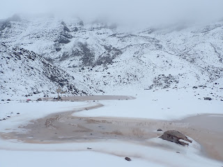
My initial plan had been to do Cotopaxi as a warm up climb and then do Chimborazo next. When I actually met the guide operator (John) and sat down with him to set out the plan we switched things around. The weather forecast for Cotopaxi that week was bad and better on Chimborazo. Despite not being that far from each other the two mountains can have very different weather patterns. It is possible to drive to the Refugio on Chimborazo at 16,000’.
 First view of Chimborazo
  Refugio Carrel
 This was a really nice Refugio with clean bathrooms and a warm dormitory. I spent two days and nights there acclimatizing and hiked up to 18,000’ both days to further get my body used to being so high. The first night I had an altitude headache (Imagine a bad hangover) but by the second night it had completely resolved. It snowed the first two afternoons I was there which made conditions on the mountain worse.
 Fog was a common phenomena
  Fresh snow made conditions more difficult
Both those days the reports were that a couple of people made it to the top but that most had to turn around. To avoid avalanche hazard people start this climb at 11pm to time getting to the summit around sunrise. It is not good to be on the mountain after mid-morning as the sun warms up the snow. While at the Refugio I was pleasantly surprised to find out one night that the climber sitting next to me was from Iran. The Ecuadorians got nervous about an American and Iranian sitting next to each other but we rapidly showed them that the Iranian people are actually big fans of Americans. He was amazed when I was able to turn to him and say in Farsi, “My name is John. I am pleased to meet you. I am a friend of Iran. I only speak very little Farsi.” Saman was one of only 2 that summited the night before my attempt. The night I climbed it was windy and the entire mountain was inside a cloud. From the Refugio it is a long way and 4500’ of vertical to the summit. The first third of the way is on dirt and then the rest is straight up a huge glacier.
 View of route from acclimatization climb
 I call this a Nepali route. No switchbacks, just straight up the mountain. I was warm enough but it took every layer I had – two shirts, a wind breaker, a puffy jacket, my shell, and then my high altitude big down jacket on top of that. All my clothes were covered in frost and ice from the cloud around us freezing on me. I had double boots and crampons on my feet and high-altitude mittens for my hands. I could not really take my mittens off without my fingers instantly getting cold and we were always in the fog so I didn’t take any pictures. The fresh snow from the previous days had created some crusty wind slab which made the footing more difficult and was a potential avalanche hazard once the sun came up. We got to the first summit just at dawn. It was really hard to breathe on the last 1500’. I would take two steps forward and then have to stop and take 6 breathes to recover. From the first false summit it is another 30 minutes of walking across the summit plateau to get to the true summit. Only me and a German guy (with our guides) made it to the summit. The other 6 people that started with us from the Refugio ended up turning around. Even going down was a struggle in the thin air. I made it back to the Refugio but was completely spent by the time I got there. Both my water bottles had frozen so I was dehydrated and the climb had pushed me to my physical limits. My guide that night was Juan Silva who had climbed the mountain over 600 times. For this climb I didn’t really need a guide but it was nice to have him since he knew the route despite the thick fog.
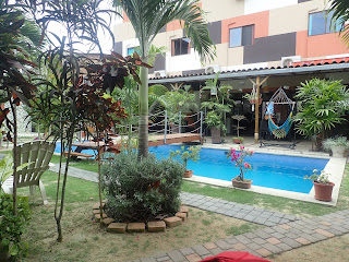
I then went down to Riobamba to recover. I definitely needed some time but once again my tour operator John went radio silent on me and I ended up spending 2 more days there than I had wanted to. It turned out that he was on another mountain. His office was very close to where I was staying and I found out from a neighbor when he was returning. I went over to his house when that happened and we made a plan for Cotopaxi. The weather forecast was not good for the next 5 days and reports were that people were not even able to leave the Refugio there due to the high winds and snow. I decided to go down to the coast and sit on the beach while waiting for a weather window. I caught a bus to Puerto Lopez which is a small (but growing) fishing village. It was much hotter on the coast then it was in the highlands. I found a great hotel a block from the beach. I would run the beach every morning and then come home and float in the pool.
 Recovery pool in Puerto Lopez
It was the perfect temperature – not hot or cold. I would float on my back for an hour after the run and almost fall asleep. The hotel also had an excellent kitchen with Spanish cuisine. I could have spent a week there but only had 3 days before the forecast told me to get back up into the mountains.
It took a tuk tuk and 3 buses to get from Puerto Lopez to the park entrance of Cotopaxi. The bus basically just dropped me off after dark in the middle of nowhere on the side of the Pan American Highway. At first I wasn’t even sure I was in the right place but a park ranger drove by and offered to give me a ride to my hotel.
 First view of Cotopaxi
 Everything seemed to be on track for heading up Cotopaxi but when the guide came to pick me up it turned out that the park service would not issue me a permit. There was a backlog of climbers trying to summit from the previous bad weather and there were too many people on the mountain. The tour operator John made some phone calls and switched me over to another guiding company that did have permits for the next night so it only ended up being a 24-hour delay. My guide for this climb was Flavio Armas who was very experienced and has climbed all around the world. The Refugio on Cotopaxi was also nice but cold. During the day it was colder inside than it was outside. The weather was perfect for the summit attempt. The moon was out so there was some light and you could see the lights of Quito not that far off.
 Lights of Quito on summit night
There was some light wind but it was a warm night. I never needed my thick parka. Like Chimborazo, the lower third of the route is dirt and then gets onto the glacier. This mountain is much more complicated than Chimborazo. There are multiple crevasses, seracs, cliffs, and steep icy slopes. It is also an active volcano.
 Not a simple route up the mountain
It seemed much more dangerous than Chimborazo had been due to these hazards. Despite this, Cotopaxi is the most popular climb in Ecuador. I saw people with very little mountaineering experience that night as some of them didn’t even know how to put their crampons on. The foot path that was tracked was only 8 to 12 inches wide in most places. If you slipped or tripped with your crampons there was often spots where there could be drastic consequences. Being fully acclimatized and it being a shorter route and mountain I felt good that night. I was able to keep a 1:1 ratio rest step going all night – 1 step, 1 breathe. I kept a pace where I never got light headed and was able to concentrate on my foot placement so I didn’t accidently catch a crampon in my pant leg or something stupid along those lines. All the snow bridges over the crevasses were solid and there were no issues. Most people who started that night made it to the summit. We topped out just as the sun was coming over the horizon.
 Sunrise from Cotopaxi summit
The caldera of the volcano was much bigger than I expected and huge clouds of steam and sulphur were swirling out of the ground. It is a weird feeling looking down a giant hole that connects to the molten center of the Earth.
 View into cauldera
 In the distance the other volcanos of Ecuador could be seen including Chimborazo. On the way down it was in brilliant sunshine and under dark blue skies with low clouds in the valleys below.
 Crevasses on the way down
  Gorgeous views on descent
 Breakfast was waiting at the Refugio and then shortly afterwards we hiked the short distance to the parking lot and drove back to town.
After Cotopaxi I only had time to catch the bus to Quito the next day and then fly home the day after that. I would have liked to have had more time to explore Ecuador but the climbs were the main reason for the trip. The mountaineering here was excellent and I would highly recommend it if you like doing this sort of thing. I know that this will not be the last time in this part of the world. The Andes are my favorite mountain range in the world and since they stretch the length of the continent for 4000 miles there is a lot to explore. However, next time I come back it will be with Kathleen. We have a lot of good memories from all over the world but we always seem to have an even better time in South America.